The Churches of Britain and Ireland
| East Grinstead,
West Sussex
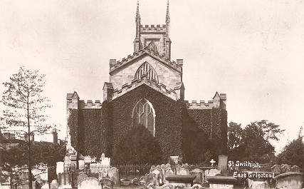
Church of Jesus Christ of Latter-day Saints (2024 Streetview) on Ship Street and West View Gardens. TQ 3938 3788. The former First Church of Christ, Scientist (2015 Streetview) on Cantelupe Road, now an office. Genuki supplies dates of 1930 (founded) - 1985 (closed). TQ 3952 3817. The former Friends' Meeting House (the yellow-painted building in the background) on Station Approach, as seen by Streetview in 2024. Its Wikipedia entry says "Opened in the early 1950s, extended in 1957 and closed in the 1980s". It's now in use as a nursery. TQ 3912 3824. Jubilee Community Church (2024 Streetview) on Charleswood Road. TQ 3902 3902. Link. Kingdom Hall of Jehovah's Witnesses is on London Road at TQ 3909 3841, and was seen by Streetview in 2024. They had previously met in a nearby Salvation Army Hall (now demolished), also on London Road, at TQ 3910 3840. In a Streetview from 2024 the site of the old S.A. Hall can be seen directly in front of the camera, with the new Kingdom Hall on the corner to the right. A former Mission Hall stands on De La Warr Road at TQ 3968 3818. Seen by Streetview in 2021 (here and here), it's evidently now in secular use. The lintel over the door seems to have some defaced lettering, but I can't make it out. Some history here. Moat Church (U.R.C.) on London Road is labelled as Congregational on a map of 1878. An old directory says it was built in 1871. Streetviews in 2024, 2021, 2019. TQ 3906 3846. Link. The cemetery off Queen's Road shows a double Mortuary Chapel on older O.S. maps, aligned roughly N.W.- S.E. The more northerly is labelled as CoE, the other as Nonconformist. Not seen by Streetview, an old photo can be seen here. TQ 3911 3802. Our Lady and St. Peter (R.C.) on London Road at TQ 3901 3847, as seen by Streetview in 2024 and 2023. Its grade II listing dates it to 1897-8. Link. St. Mary the Virgin (2024 Streetview), on Windmill Lane, as seen by Streetview in . It post-dates a map of 1878 (Pevsner dates it to 1891-1912). TQ 3866 3893. Link - a church video tour can be followed from a link towards the bottom of the page. St. Swithun. From an old postcard (where it's spelled Swithin) franked in 1919, in Steve Bulman's Collection. A good modern photo here on Geograph, and more can be found here. The interior (on an external website). TQ 3965 3799. Link1. Link2. Grade II* listed, wherein it says that the church was re-built from 1789, with the tower of 1812. It stands on the site of its medieval predecessor, some details of which are included in the listing. Also listed (at grade II) is the churchyard gateway. The Hope Church (R.C.C.G.) meets in the Kings Centre (2019 Streetview) on Moat Road. TQ 3931 3841. Link. Trinity Methodist Church (2024 Streetview) is on Lingfield Road and London Road. On available maps, it first shows in the middle of the last century. TQ 3873 3876. Link. West Street Baptist Church (on West Street) is dated 1810, as Zion Chapel, and was seen by Streetview in 2024. TQ 3944 3799. Link. The history page has several old photos and illustrations. An earlier Baptist Chapel shows on London Road on a map of 1899, at TQ 3887 3861. Closed before the 1960's, it has since been demolished, its site marked roughly by the alleyway alongside the garage seen by Streetview in 2024.
|
||
17 December 2025
© Steve Bulman
Contact Details