The Churches of Britain and Ireland
| Banbury, Oxfordshire
Churches in
Grimsbury. Banbury Community Church (Evangelical) meets in the The Mill Arts Centre (2022 Streetview) on Spiceball Park Road. SP 4593 4073. Link. All that remains of Bridge Street Baptist Chapel is the portico. Its grade II listing dates it to 1839. SP 4574 4058. © Gervase N. E. Charmley (2012). Of Christchurch (CoE), all that survives is the church hall on Broad Street. It appears to be the same building (or is on the site of) a school marked on a map of 1900, but this source says it was a Sunday School and parish room, and dates it to 1884. © Gervase N. E. Charmley (2012). The church itself stood at the corner of Fish Street (now George Street) and Broad Street, at SP 4572 4044. It's dated here (where there is a photo) to 1851, demolished in 1970. The housing built on its site was seen by Streetview in 2022. The former Congregational Chapel (1857) on South Bar Street. Another view. SP 4535 4036. Both © Gervase N. E. Charmley (2012). Gervase advises that it was built for the Rev. Joseph Parker, later famed for his ministry at the City Temple in London. Grade II listed. Easington Methodist Church is on Grange Road, and was seen by Streetview in 2022. SP 4557 3899. Link. The former Ebenezer Chapel stands very close to Austin House, on a side street. A map of 1881 labels it as Particular Baptist. SP 4538 4019. © Steve Bulman.Exclusive Brethren meeting-room on Beargarden Road. SP 4506 4019. © Gervase N. E. Charmley (2012). As of 2024, Google Streetview is labelling it as "permanently closed". Fairway Methodist Church on The Fairway and Hope Close, seen by Streetview in 2022. SP 4424 4089. Link. A Friends' Meeting House stands off Horse Fair at SP 4532 4058. Seen by Streetview (the hipped roofed building) in 2022, it's dated here to the 17th century. Its grade II listing says 1681, and 1749-51. Link. Methodist Church on Marlborough Road at SP 4553 4034. It's marked on older maps as Wesleyan. © Steve Bulman. Interior view, © Gervase N. E. Charmley (2012), who advises that the interior was re-constructed in 1975. Link. People's Church on Horse Fair previously a Baptist Church, built on the site of Unitarian (and before that, Presbyterian) Meeting House. This source dates the present building to 1973. It also dates the Presbyterian Chapel to 1716, changing to Unitarian in 1850. SP 4526 4055. © Gervase N. E. Charmley (2012). Link. See also the Unitarian entry, below. Redeemed Christian Church of God Lighthouse meets in this building (2022 Streetview) on Manor Park. SP 4628 4174. Link. St. Francis (Anglican, Methodist and U.R.C.) on Highlands, as seen by Streetview in 2017. SP 4465 4209. Link. St. Hugh (2022 Streetview), on Ruskin Road. SP 4507 3938. Link. St John the Evangelist (R.C.) on Dashwood Road. SP 4537 4016. © Steve Bulman. Link. Grade II listed, wherein it's dated to 1838.St. Joseph the Worker (R.C.) on Edmunds Road, as seen by Streetview in 2009. SP 4391 4038. Link. St. Mary the Virgin (CoE and U.R.C.). It's dated in its grade I listing to circa 1790. SP 4541 4055. © Steve Bulman. Interior view, © Simon Edwards (2011). Link. For the numerous listed headstones and tombs, etc., see here. St. Paul on Warwick Road, as seen by Streetview in 2020. SP 4500 4094. Link. Salvation Army Citadel on George Street (previously Fish Street). SP 4560 4048. © Gervase N. E. Charmley (2012). Link. Sheikh Bin Baaz Masjid on Park Road. According to the map on their website, it's the house with the small roof over the door, seen here in a Streetview in 2022. SP 4468 4061. Southam Road Evangelical Church (Independent), on Southam Road and Cope Road. Another view. SP 4534 4092. Both © Martin Richter (2011). Link. A stone cross is all that remains of the former Unitarian Church. SP 4526 4055. © Gervase N. E. Charmley (2012). See also the People's Church entry, above.
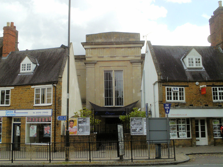
The former Wesleyan Chapel (1812) on Church Lane, was sold to the Primitive Methodists in 1865.
SP 4550 4058. © Gervase N. E. Charmley (2012).
Grimsbury
|
||
18 May 2024
© Steve Bulman