The Churches of Britain and Ireland
| Wednesbury, West Midlands
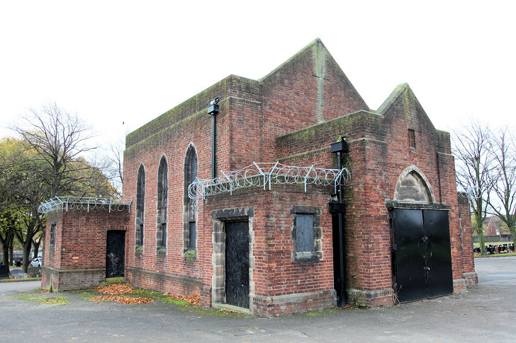
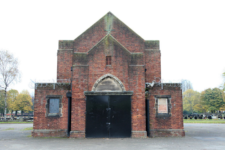
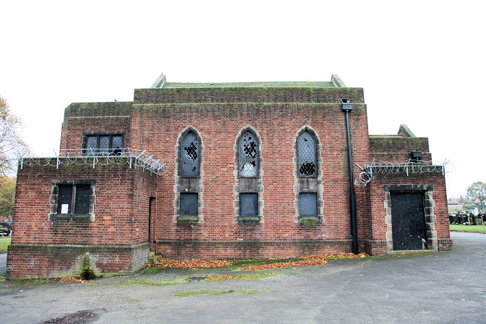
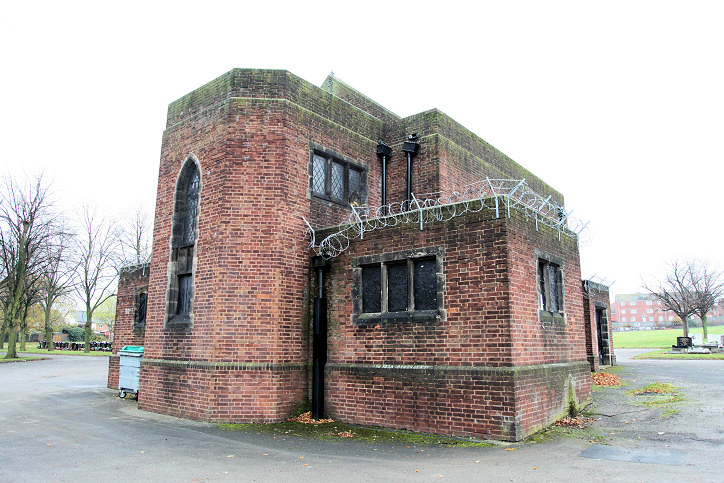
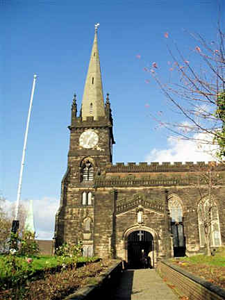
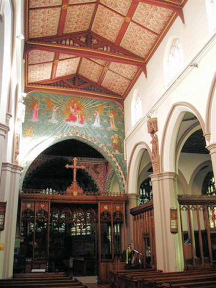
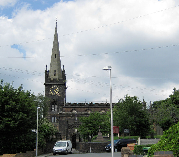
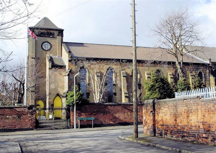
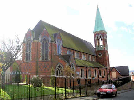
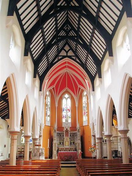
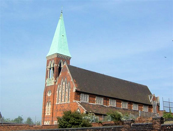
The former Baptist Chapel on Holyhead Road, as seen by Streetview in 2023. It's labelled as Baptist Chapel (Particular) on a map of 1889, and identified here as originally having been Congregational, from whom the Baptists bought the chapel in 1848. SO 9869 9468. There used to be a Free United Methodist Chapel on Ridding Lane and Addison Street, shown on a map of 1888 at SO 9896 9487. It survived in active use into the mid-20th century at least. This source says "The Wesleyan Reform Connexion sometime after 1849 build [sic] a chapel in Ridding Lane. This Society became a Free Methodist Church. The chapel was unused for around 20 years when the roof collapsed in 2017". What seems to have been part of it survives (2023 Streetview). Kingdom Hall of Jehovah's Witnesses on Cobden Street, as seen by Streetview in 2023. SO 9865 9670. Lea Brook Methodist Church on Lea Brook Road North and Bannister Road was originally a Primitive Methodist Sunday School. SO 9790 9448. According to this source, the original chapel of 1850 was demolished in 1937. It's very likely that it was the Chapel showing on older O.S. maps a short walk to the N.E. at SO 9793 9454. In this Streetview from 2022 the present church is at the extreme left; the old chapel stood on the same side of the road about where the tallest tree is in the middle distance. © John French. Masjid Al-Madani (2022 Streetview), on Walsall Street. This was originally Trinity Congregational Chapel, dated here to 1904-5. SO 9908 9514. Link. Wednesbury Cemetery on Beebee Road has (for the moment, anyway) a Mortuary Chapel. Dennis advises that it hasn't been used for years, and following recent vandalism, the local council is proposing to demolish it. Added 2013 - the chapel was demolished earlier this year. Additional views - 1, 2, 3, 4. SO 9872 9639. All © Dennis Harper (2012). Wood Green Cemetery on Wood Green Road had a double Mortuary Chapel, centred on SO 9955 9564. Aligned roughly north-south, the northern one was Nonconformist, the other Church of England. In this Streetview from 2017, looking east, the site where they stood is where the path widens out. A Chap. shown on older O.S. maps on Camp Street was Primitive Methodist, dated here to 1824. Its site now lies beneath Morrison's, where the road goes underground. SO 9864 9483. There used to be a Primitive Methodist Chapel on Vicarage Road at SO 9920 9549. It pre-dates a map of 1889, and had gone out of use no later than 1949. Housing has been built on its site (2023 Streetview). St. Bartholomew and the interior. SO 9871 9533. Both © Aidan McRae Thomson. Another view, © Chris Emms (2009). Link. Grade II listed - it dates it to circa 1827, "with C14 remains". St. Francis of Assisi on Freeman Road and Keir Road was seen by Streetview in 2021, 2020, and 2022. Its grade II listing dates it to 1938-41. SP 0061 9495. Link. The history page has several interior photos, and says that the church was preceded by a wooden mission church, but doesn't specify its location. St. James on St. James Street. SO 9827 9491. © Dorothy Turley. Link. The history page dates it to 1847-8. St. John used to stand on Lower High Street at SO 9879 9471. This source, which includes an illustration, dates it to 1845-6, says it was derelict in 1980 and demolished five years later. The housing built on its site was seen by Streetview in 2020. Another church, replaced by housing was St. Luke, on Alma Street. St. Luke's Mission was founded in 1879, subsequently enlarged, and "survived until the 1970's" (source). SO 9966 9512. 2022 Streetview. An earlier Streetview from 2011 (before the housing was built) shows a stretch of low wall which conceivably could have been a fragment of the church, but it's unlikely to have survived. The present St. Luke's Church and Centre (2022 Streetview) is also on Alma Street, but a little further north on the corner with Elwell Street. SO 9969 9521. Link. St. Mary on the Hill (R.C.), on St. Mary's Road. Its grade II listing dates it to 1873-4. Interior view. SO 9868 9541. Both © Aidan McRae Thomson. Another view, © John French. Link. St. Paul at Wood Green. SO 9973 9609. © Chris Emms (2009). Link. Grade II listed, wherein its consecration is dated to 1874. St. Peter used to stand on Meeting Street, at SO 9834 9515. Pre-dating a map of 1889, it survived well into the last century, but was demolished at some point, and housing built on the site (2022 Streetview). Wednesbury Baptist Church (2022 Streetview) is on Vicar Street and Hardy Road. It's described here as an ex-Methodist chapel, the Baptists moving in in 1961. SO 9918 9541. Facebook. Wednesbury Central Mosque on Spring Head, as seen by Streetview in 2023. SO 9892 9505. Link. Marked only as Chapel on all available maps, this source identifies it as a Wesleyan Methodist Chapel, later Mission, built in 1861. Its site was seen by Streetview in 2021. SO 9979 9524. Spring Head Car Park (2023 Streetview), on Spring Head and Walsall Street, is the site of a Chapel, shown on a map of 1889 as Wesleyan. There's a photo of it here, where it says it was built in 1867 on the site of a predecessor of 1760. SO 9894 9504. Another Chapel stood on Holyhead Road and School Street, at SO 9825 9504. No available maps identify it more closely, but it's likely to have been the Wesley(an) Chapel mentioned here, built in 1849. It was still active in the mid-20th century, but has since been demolished, and even School Street has vanished. Its site was seen by Streetview in 2023. The chapel was on a different alignment and stood roughly in line with the nearest tree heading back towards the block of flats with the two white gable ends.
|
||
15 January 2024
© Steve Bulman
Contact Details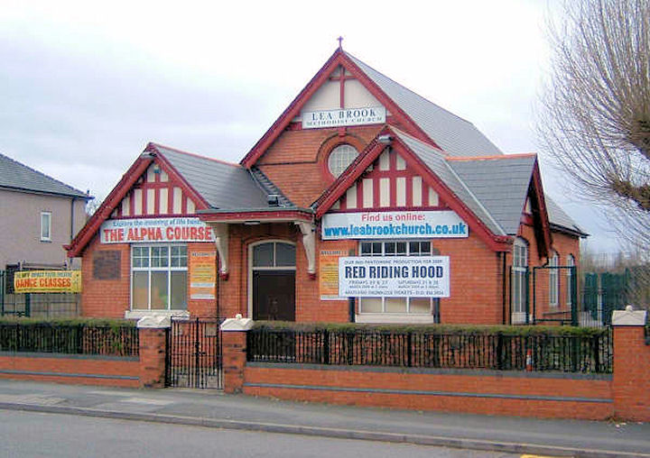