The Churches of Britain and Ireland
|
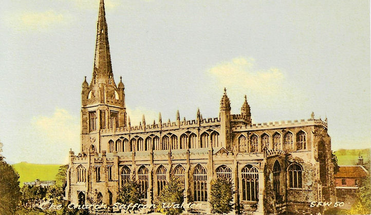
Saffron Walden, Essex Abbey Lane U.R.C. (earlier Congregational), as seen by Streetview in 2023. It's dated 1811. TL 5360 3834. Link. Grade II listed. Gold Street Chapel isn't labelled on any available maps, but it is mentioned here in a history of the Community Church, as being their previous home. It was seen by Streetview in 2018. TL 5382 3823. The Friends Meeting House (2023 Streetview) on High Street. Link advises that the present building dates from the 1870's, on an older site. TL 5374 3826. Kingdom Hall of Jehovah's Witnesses off Rowntree Way, as seen by Streetview in 2014. TL 5369 3731. The cemetery on Radwinter Road (earlier Sewers End Road) had two Mortuary Chapels, Nonconformist at TL 5461 3842, and Church of England at TL 5469 3843. On a map of 1881 these are labelled as Mortuary Chapel (Dissenters) and Mortuary Chapel (Episcopal) respectively. The nonconformist chapel hasn't survived, but the CoE has, and a photo of it can be seen here. It's listed as grade II, wherein it's dated to 1857. The cemetery railings and gates are also listed at grade II. Our Lady of Compassion (R.C.) - 2023 Streetview - on Castle Street, is listed at grade II, where it says that it was originally stables. TL 5365 3863. Link1. Link2. A former Primitive Methodist Chapel stands on Castle Hill at TL 5393 3874. It's dated here to 1868, closing in 1937, and was seen by Streetview in 2023. Saffron Walden Baptist Church is on High Street and Audley Road, and was seen by Streetview in 2023. At its rear, wholly on Audley Road, is an earlier Chapel (2023 Streetview). Pevsner dates them to 1879 and 1774-5 respectively. TL 5383 3817. Link. The earlier chapel is listed at grade II. A former Baptist Chapel, dated 1822, on London Road is now The Old Chapel (2023 Streetview). A comment in its grade II listing implies that it had been home to Christian Scientists at some point. TL 5367 3800. There is another former Baptist Chapel, off Hill Street, at TL 5397 3841. Now known as Sullivan House, it can't be seen on Streetview, but there's a good photo here. Its grade II listing dates it to 1792, as a General Baptist Chapel. Saffron Walden Community Church (2018 Streetview) on Castle Street. It's dated in its grade II listing to 1864-8, as Wesleyan Methodist. TL 5376 3873. Link. St. Mary the Virgin. TL 5373 3862. From an old postcard (franked 1904) in Steve Bulman's Collection. Another old postcard, from Christopher Skottowe's Collection. Link. Grade I listed. For other listed features associated with the church, see here. The Salvation Army Church stands off Abbey Lane, close to the U.R.C., at TL 5360 3837. It's the building in the background with the small spire, seen by Streetview in 2015. O.S. maps mark the site of a Priory (Walden Benedictine Abbey), at TL 5262 3816. After the dissolution, Audley End House (2011 Streetview) was built on or near its site. Wikipedia entry.
|
||
26 August 2025
© Steve Bulman
Contact Details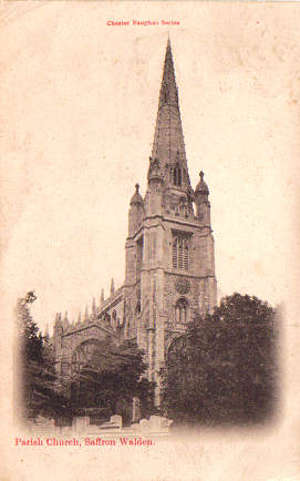