The Churches of Britain and Ireland
|
Ferryhill, County Durham
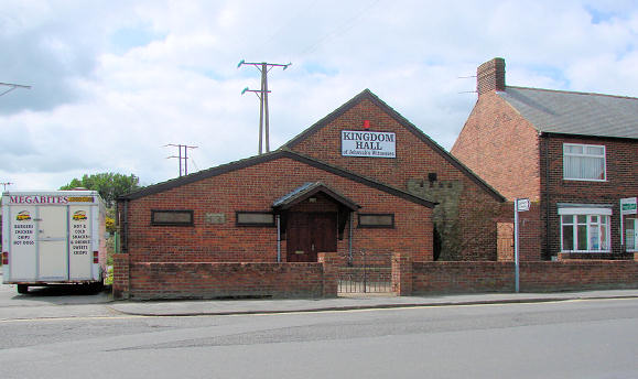
A short-lived Apostolic Church is shown on old maps in Ferryhill Station, at NZ 3022 3203. Built some time after 1920 and before 1939, it had gone by 1961. In this 2009 Streetview, it stood further up the lane on the left hand side. An Assembly of God Pentecostal Church stands or once stood on North Street, at NZ 2892 3291. The building may survive - see the white building gable-end on to, and set back from, the street in the background of this 2018 Streetview. The former Baptist Church on St. Cuthbert's Terrace, Dean Bank. NZ 2850 3265. It was still active when the Streetview van passed in 2010, but by 2016 had closed, and was in use as The Enter Centre. The site (the area of grass bounded by the low fence) of the Independent Methodist Chapel, as seen by the Streetview van in 2009. It was built before 1920, a little way south of Watt Street in Dean Bank, on what seems to have been an un-named side street, and it appears to have survived into the 1990's. A photo of part of the church, with the church sign board, is available here. NZ 2828 3265. Kingdom Hall of Jehovah's Witnesses, which dates from the 1970's or early 1980's. NZ 2967 3212. A Mortuary Chapel stands in Duncombe Cemetery off Cleves Avenue, at NZ 3015 3228. Although the chapel itself can't be seen on Streetview, the entrance to the cemetery was seen in 2009. The former Broom Primitive Methodist Chapel stands at the eastern end of Dean Road, at NZ 2936 3224. Converted to residential use, it can be seen in this 2016 Streetview. Durham Record Office references registers for the chapel from 1938 to 1986 - see here. The Methodist Church in the Market Place was originally Primitive Methodist. NZ 2886 3285. A 2010 Streetview. The church website dates its opening to 1910. This must refer to the present building, as a map of 1897 shows a Meth. Chap. (Prim.) on the same site. St. Cuthbert (presumably CoE) stood on St. Cuthbert's Terrace, Dean Bank. Built before 1920, it doesn't seem to have survived beyond the 1960's. Now just a patch of grass, the site can be seen in this 2010 Streetview. NZ 2829 3259. St. Luke on Church Lane, as seen by the Streetview van in 2016. Another Streetview from 2009. Its grade II listing dates it to 1853, when it was successor to a church of 1820 in the market place. Link. The former St. Mary's and St. Martha's Chapel stands almost opposite the Kingdom Hall (above), and is now used by a firm of undertakers. It was also known as St. Martha's and St. Mary's. Old maps imply that it was built between 1920 and 1939, a map of the later date labelling it as Mission Room. Janet Gimber (who provided the identification) advises that the chapel seems to have closed in the mid-1990's. NZ 2973 3215. Both © Bill Henderson. At one time a Salvation Army Barracks/Hall stood at the east end of Newton Street, Dean Bank. Still active circa 1965, two photos of S.A. people can be seen here (one outside, one inside), in the Dean Bank section. At the time of the Streetview van image (2009) it was a patch of grass. NZ 2849 3274. A Wesleyan Methodist Chapel stood on Kelvin Street, Dean Bank, at NZ 2819 3257. Known as Westcott Methodist Church in 1940, the site has been put down to grass, as seen here by Streetview in 2009. The former Zion Primitive Methodist Chapel stands on Siemans Street and Rennie Street in Dean Bank. The Streetview van saw it in 2010. Built by 1920, it was still labelled as Ch. on a map of 1980, and by 1989 was labelled as Hall. NZ 2844 3259.
|
||
04 March 2023
© Steve Bulman