The Churches of Britain and Ireland
|
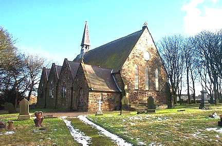
Coundon, County Durham St. James (1871-3). NZ 2361 2978. © Bill Henderson. Curiously the grade II listing fails to mention that it was successor to an earlier church close by to the N.N.E., south of Collingwood Street, where it joins Church Street. No trace remains, the land now forming part of the churchyard, but where it stood can be seen on a 2009 Streetview. Howard Richter has found on-line sources which mentions surviving records from the church for the years 1842-1863, though presumably it continued in use until the new church was completed in the early 1870's. St. Joseph (R.C.) stands on Victoria Lane at NZ 2410 2975, and can be seen on a 2009 Streetview here. A map of 1939 shows it, though the preceding one of 1920 doesn't. The National Archives lists records from 1911, though whether this is the date for the active church is unclear. Link. Howard Richter has also advised of the following five former and demolished churches - A Methodist New Connexion Chapel stood not far from St. Joseph, at NZ 2411 2978. Absent from the 1856 map, it had been built by the time of the 1897 map, and was later shown as United Methodist (1920) and Methodist (1939). It was still active in 1940. The building was still extant, but un-named, on the 1962 map, and had been demolished by 1971. At the time of the Streetview visit, it was a small car park. The former Primitive Methodist Chapel of 1885 stands at NZ 2409 2956. Still showing as "Meth. Ch." on the 1971 map, it had been converted to industrial use by the time of the 1987 map. Streetviews - 1, 2. Only labelled as a Salvation Army Hall on the map of 1962, it stood at NZ 2396 2984. Not shown on the 1920 map, the 1939 has it as "Hall", and the 1971 as "Scout Hall". A house now stands on the site, seen here in a 2009 Streetview. A Spiritualist Church is shown on a map of 1930, at NZ 2373 2974. The preceding map of 1920 (the first to show it) marks it as Chapel, and by the time of the 1962 map it was Assemblies of God (Pentecostal). The Streetview camera passed by in 2009, and shows a building which appears to be secular. A demolished Wesleyan Methodist Chapel once stood on the main road at NZ 2378 2976. Built prior to the compilation of the 1856 map, it continued to be shown as a Methodist Church until the map of 1987, but the 2009 Streetview shows that it has been replaced by housing.
|
||
19 July 2025
© Steve Bulman