The Churches of Britain and Ireland
|
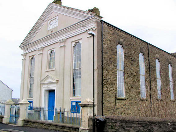
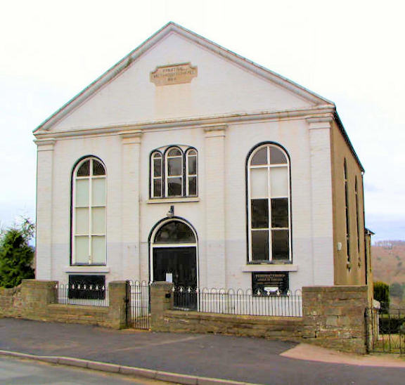
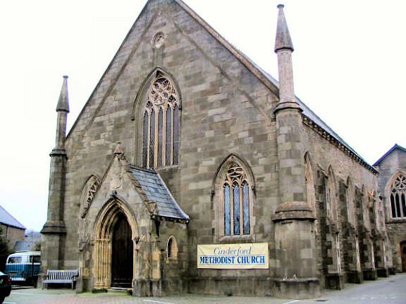
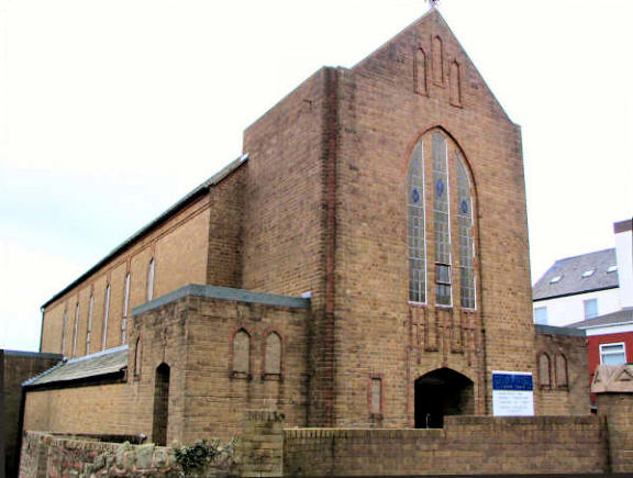
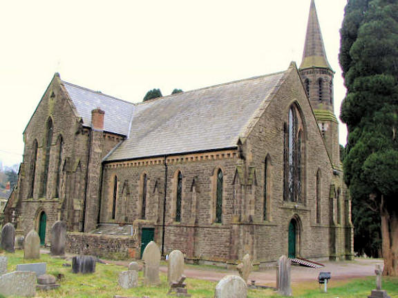
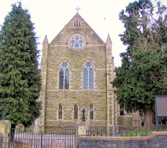
Cinderford, Gloucestershire Baptist Church on Commercial Street. SO 6561 1382. © Graeme Harvey. Grade II listed, wherein it's dated to 1860. . Bethel Baptist Chapel stands on an apparently un-named road off Steam Mills Road at SO 6500 1548. Kelly's Directory of 1897 dates it to 1880, with enlargement and the addition of a schoolroom in the 1890's. It was seen (distantly) by Streetview in 2021. A Bible Christian Chapel once stood on Abbey Street at SO 6579 1379. This source dates it to circa 1875-9, with the chapel known to have been home later to Plymouth Brethren (1879-1921) and Pentecostal congregations, the latter being known as Abbey Street Christian Fellowship, active in the 1960's. Closed in the 1990's, the house built on its site can be seen in a Streetview from 2009. See also Forest Community Church, below. The former Bilson Mission Church on Upper Bilson Road. It consists of two tin tabernacles, seen by Streetview in 2009 - 1, 2, 3. SO 6533 1452. A photo is available here, where it's dated to 1880 on a different site, and on the present site since 1900. Now closed, the congregation apparently met at Hanover Court, off Valley Road, seen here in a Streetview of 2009, but these services may no longer continue. SO 6513 1405. Forest Community Church on Station Street, as seen by Streetview in 2018. Originally Plymouth Brethren - who moved here in 1921 from the Abbey Road building (see the Bible Christian entry, above) - the present congregation arrived in 2005 (as a plant from Glebe Chapel in Newent [source]), with the first service held in March 2006. SO 6548 1413. Services were held for some time in The Forest High School (previously called Heywood School, seen by Streetview in 2018, SO 6605 1458) on Causeway Road, until 2016, when they returned to their enlarged Station Street premises. Link1. Link2. According to this source there was a Friends' Meeting House on Station Street at SO 65356 14046, and, quoting from another source, dates it to "before 1931 to "after 1970". A wooden building, its site can be seen here and here, in Streetviews from 2009. A former Methodist Church (originally Primitive Methodist) stands on Church Road at SO 6538 1312. Previously incorrectly identified here as Wesleyan, it was seen by Streetview in 2009, showing that the painted render had been removed - presumably as part of its conversion to residential use in the previous year. It has a date-stone for 1864, and this source says they had previously met in a rented room from 1859. © Graeme Harvey. Link. The former Methodist Church on Belle Vue Road. Originally Wesleyan, it has a date-stone for 1849. SO 6582 1398. © Graeme Harvey. It has evidently closed fairly recently, as there is an Estate Agent notice here, with interior views. Some history here, where it says that it replaced a predecessor - Littledean Hill Chapel - the precise location of which is uncertain. (Littledean Hill is a short distance east of Cinderford. Grade II listed. Another former Methodist Church (originally Wesleyan, 1869) stands on Railway Road at Cinderford Bridge. SO 6509 1256. Streetview saw it in 2009. A Mission Hall once stood on Elton Road, at Little Dean Hill. It pre-dates a map of 1878, and its site now lies beneath a road junction, seen by Streetview in 2009. Latterly it was used for parochial meetings connected with St. Stephen's Church, so perhaps it was originally a mission from there. It was seen by Streetview in 2009, here and here. SO 6641 1415. Our Lady of Victories (R.C.) on Flaxley Street. It's dated here to 1939, services having previously been held in a hotel. SO 6593 1362. © Graeme Harvey. Link. A Particular Baptist Chapel once stood at the junction of Forest Road and Woodside Street, at SO 6573 1376. Named as such on a map of 1878, it was later a Congregational Chapel, and from 1964 it was a Kingdom Hall. Its site was seen by Streetview in 2009. St. John the Evangelist. SO 6529 1278. © Graeme Harvey. Grade II listed, wherein it's dated to 1844. St. Stephen. Its grade II listing dates it to 1890, with the chancel added in 1893. A 2018 Streetview provides another view. SO 6590 1383. © Graeme Harvey. St. Stephen's Hall on Forest Street was originally a school, and later a Mission Room (so marked on a map of 1922). Two Streetviews from 2009 - 1, 2. SO 6578 1376. The former Sion (or Zion) Wesleyan Methodist Chapel of 1860 on High Street, as seen by Streetview in 2021. From 1885 it was Bible Christian, and later United Methodist, who sold it in 1917 to the YMCA. At some point it was extended forward or demolished and re-built (on older maps it shows as being in line with the adjacent buildings). It's now used as a snooker hall. A more extensive history can be seen here. SO 6557 1439. The 6" O.S. map published in 1953 identifies a church on Station Street with the label The Ark. This was a tin tabernacle Mission Hall, and its story can be read here, where it says that it was registered by the Blue Ribbon Gospel Army in 1886, closed in 1973, and subsequently used by the town band. Later demolished, a bungalow now stands on the site, seen here by Streetview in 2009.
|
||
04 March 2023
© Steve Bulman