The Churches of Britain and Ireland
| Bulwell, Nottinghamshire
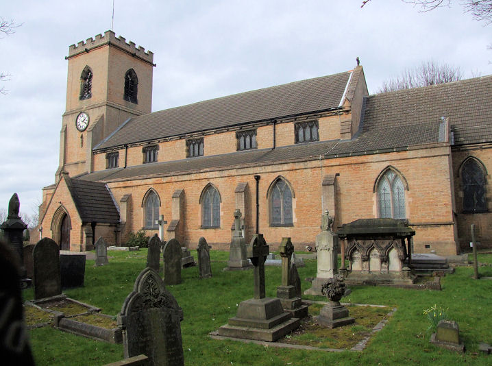
Bulwell Baptist Church on Main Street was seen by Streetview in 2024. This source dates it to 1929-30. SK 5397 4479. Link. Its predecessor shows on a map of 1885, just a few steps further north at SK 5398 4479, its site now a car park - 2024 Streetview. Bulwell U.R.C. (2022 Streetview) is on Broomhill Road and Brooklyn Road, at SK 5461 4475. What appears to be the same building as shown on a map of 1915 as Meeting House. Link. An otherwise un-named Chapel shows on maps from the early 20th century, on the now vanished Albert Street at SK 5431 4453. A building of the same footprint and orientation shows on the earlier 1885 map, though it isn't labelled. This webpage has a photo which shows part of the chapel, taken just before the church's demolition in 1966, and identifies it as Albert Street Methodist. Its site is now close to Deptford Crescent, specifically beneath the housing in the background of a Streetview from 2022. The Church standing on Broomhill Road and Clarges Street was seen by Streetview in 2020. Not labelled beyond Church on any available map, it has the look of Methodism about it. It now appears to be in residential use. SK 5445 4465. A Meeting House shows on a map of 1900, on Coventry Road, midway between the Kett Street and Milton Street side roads, at SK 5389 4505. What appears to have been the same building appears on a map of 1885, though it isn't labelled. Milton Street no longer exists, and Kett Street is much shorter than it used to be. The site of the Meeting House now lies beneath the grass to the left of the road, about where the streetlamp is in this 2024 Streetview. Mount Zion 7th Day Church of God (2023 Streetview) is on Main Street at SK 5407 4535. It shows on a map of 1915 as S.A. Citadel, so Salvation Army. Link. Our Lady of Perpetual Succour (R.C.) on Brooklyn Road, as seen by Streetview in 2022. SK 5488 4452. Link. This source sates it to 1934-5, successor to a hut which had stood on the present site since 1920. The Primitive Methodists had a chapel on Quarry (now Commercial) Road at SK 5377 4529. It's dated here to 1888-1968, and demolished soon after. It includes photos. The row of housing built on its site can be seen in a Streetview from 2023. Ravensworth Road Methodist Church (2023 Streetview) stands on Ravensworth Road and Stockton Street. SK 5394 4542. Link. St. John the Divine on Keys Close, as seen by Streetview in 2023. SK 5348 4545. Link. Grade II listed, wherein it's dated to 1884-5 (though the About us page on ACNY says 1882-5, with work still carrying on until 1890). St. Mary the Virgin on Church Lane. The 1850 church replaced a C12 church badly damaged by weathering. SK 5418 4504. © Richard Roberts (2014). Link. A Seventh-day Adventist Church (2018 Streetview) stands on Main Street and Ragdale Road. The building shows on a map of 1915 as a United Methodist Church. SK 5415 4554. Link. The Well, a modern church on Strelley Street and Muriel Street, was seen by Streetview in 2022. SK 5388 4529. Link.
|
||
11 August 2026
© Steve Bulman
Contact Details