The Churches of Britain and Ireland
|
Bexhill, East Sussex
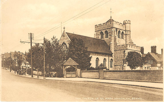
Beulah Baptist Church (2009 Streetview) on Clifford Road and the A269. O.S. maps indicate a building date of the mid to late 1950's. TQ 7439 0768. Link. Bexhill Christian Spiritualist Church on Victoria Road, as seen by Streetview in 2024. TQ 7390 0764. Link. Bexhill Masjid and Islamic Centre on Clifford Road, as seen by Streetview in 2024. TQ 7430 0757. Link. Bexhill U.R.C. on Lionel Road, as seen by Streetview in 2024. The church website has a better photo. TQ 7501 0747. Christchurch Methodist Church (2010 Streetview) on Springfield Road and Hollier's Hill. It's dated here to 1907 as Primitive Methodist. TQ 7435 0871. Link. Freedom Baptist Church (2015 Streetview) on Claremont Road and Sidley Street, Sidley. TQ 7399 0933. Link. House of Prayer on Manor Gardens. Photos can be seen on their website. TQ 7465 0793. Kingdom Hall of Jehovah's Witnesses was seen by Streetview in 2016. It stands on Terminus Road at TQ 7384 0749. Little Common Methodist Church is on Church Hill Avenue and Shepherd's Close. 2024 Streetview. TQ 7152 0781. Link. The history page dates the core of the church to 1926, and there have been several enlargements since then. It also mentions its predecessor, probably the Wesleyan chapel shown on a map of 1909 on Cooden Sea Road at TQ 7140 0779. It hasn't survived - its site (2024 Streetview). Living Word Church (Pentecostal) stands on a site between Eastwood Road and Hamilton Terrace, and was seen by Streetview in 2011. TQ 7337 0785. Link. A map of 1909 shows a Mission Hall on Hamilton Road (now Chandler Road) at TQ 7332 0797. The building on the site (2024 Streetview) would seem to be a replacement rather than a re-purposed building. The same 1909 map also shows a Mission Church on Little Common Road. It shows as still active on a map of 1955 but not on one of 1960. The building on its site was seen by Streetview in 2024 - does anything of the church survive? TQ 7359 0802. Older O.S. maps show a Primitive Methodist Chapel on Haddock's Hill (now Westwood Road) in Sidley. Pre-dating a map of 1878, it had gone out of use by the middle of the 20th century. The housing built on its site was seen by Streetview in 2024. TQ 7438 0897. A Quaker Meeting Hall stands on Albert Road, and was seen by Streetview in 2024. TQ 7424 0724. Link. St. Augustine (2024 Streetview) on St. Augustine's Close off Cooden Drive. Link1 advises of a building date of 1932. Link2. St. Barnabas (2010 Streetview) on Cantelupe Road and Sea Road. Its grade II listing dates it to 1890-1, by Blomfield. TQ 7454 0736. Link. St. John the Baptist (2024 Streetview) on Victoria Road and London Road. TQ 7394 0762. Link. St. Mark (2024 Streetview) is on Little Common Road, at TQ 7168 0797. Link1. Link2 - dates it to 1842, as a chapel of ease. St. Martha (R.C.) on Birkdale and Cooden Sea Road, as seen by Streetview in 2011 (later views are more restricted by the hedges). TQ 7148 0768. Link - dates it to 1940. St. Mary Magdalene (R.C.) on Sea Road and Magdalen Road. TQ 7459 0759. From an old postcard in Steve Bulman's Collection. The card was posted in 1957, but is evidently much older. Link. Grade II listed - wherein it's dated to 1907. St. Michael and All Angels (2024 Streetview) is on Rookhurst Road, at TQ 7586 0825. Link - dates it to the early 1930's. St. Paul (2022 Streetview) on Wickham Avenue. TQ 7353 0731. Link. St. Peter on Church Street, the parish church, as seen by Streetview in 2024. TQ 7460 0810. Link1. Link2. Grade II* listed. St. Stephen (2024 Streetview) on Newlands Avenue. Another 2024 Streetview, showing the apse. TQ 7340 0845. Link1. Link2 - dates it to 1898-1900. A former Wesleyan Methodist Chapel stands beside King Offa Way, at TQ 7410 0812. Dated here to 1822, with closure in 1938, it was seen by Streetview in 2024.
|
||
17 July 2025
© Steve Bulman