The Churches of Britain and Ireland
| Barking, Greater London
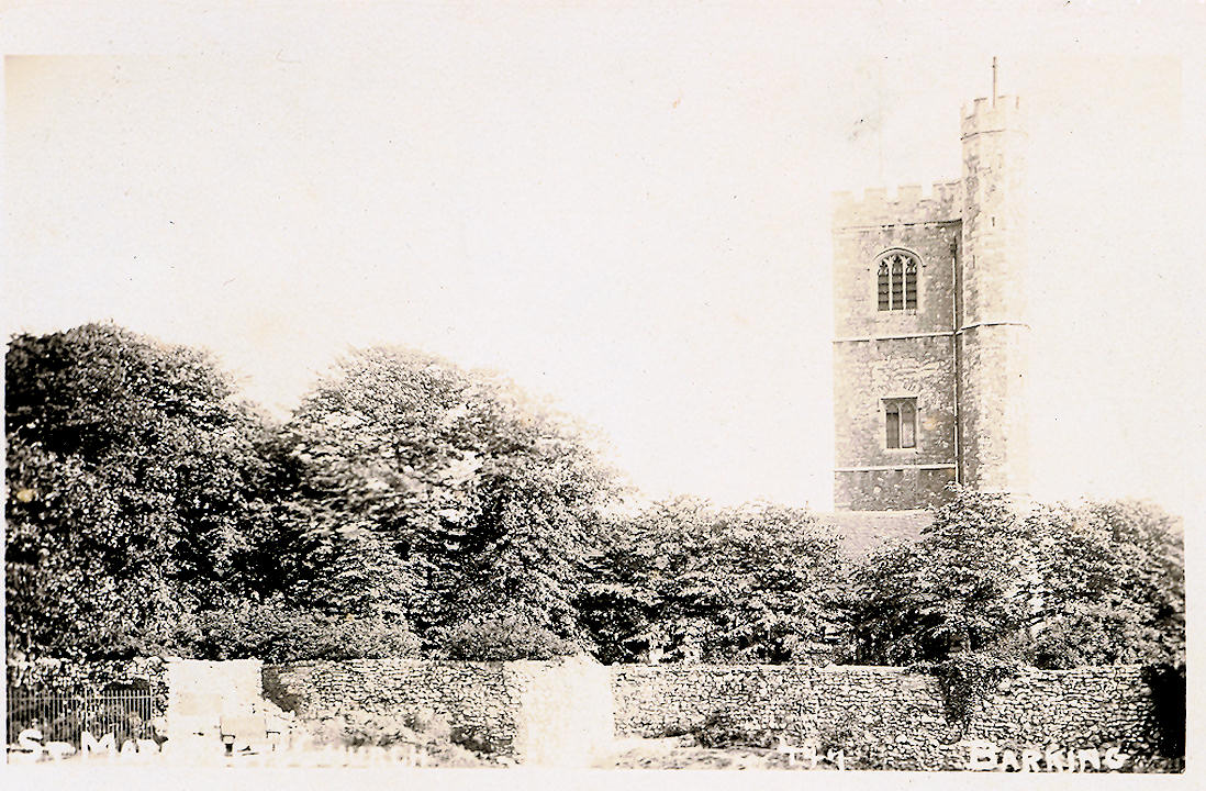
Akanjee Foundation Islamic Center on Longbridge Road, as seen by Streetview in 2025. TQ 4466 8456. Al Madina Mosque (2024 Streetview) is on Ilford Lane and Victoria Road. TQ 4416 8486. Link. At-Taqwa Islamic & Family Centre is on Longbridge Road, and seen by Streetview in 2025. TQ 4466 8460. Link. Barking Baptist Church is on Linton Road is dated 1893, and was seen by Streetview in 2018. TQ 4426 8429. Link. A Romanian church also meets here. Barking Celestial Church of Christ on King Edward's Road, as seen by Streetview in 2025. TQ 4468 8371. Barking Methodist Church is on London Road and Short Blue Place, and was seen by Streetview in 2025. TQ 4419 8415. Link. Barking U.R.C. is on Upney Lane and Salisbury Avenue, and was seen by Streetview in 2022. It had been Congregational, and is dated by Pevsner to 1929. TQ 4551 8460. Link. As of 2025, the adjacent building (church hall? - 2022 Streetview) on Upney Lane is being labelled by Google as being used by Faith Believers Chapel. Be Church (Barking Elim Church) is on Axe Street, and seen by Streetview in 2024. It presumably replaced or is on the site of a chapel labelled as Independent Chapel on a map of 1873, and on the 1897 25" map as Meeting Room. Mid-20th century maps don't show it as a place of worship. Link. Becontree and Barking Synagogue used to stand on Becontree Avenue at TQ 4708 8623. It was still active at the time of the first Streetview photo in 2008, but held its last service in 2014 (source). It was demolished in 2019-2021 and this building now stands on its site (2025 Streetview). Christ Church (2022 Streetview) is on Bastable Avenue. It's dated in Pevsner to 1958-9. TQ 4575 8315. Link. Christ Embassy Barking is on Thames Road at TQ 4669 8280, and was seen by Streetview in 2025. Link. Church at Barking Riverside is on Minter Road in the Rivergate Centre, and was seen by Streetview in 2024. TQ 4640 8232. Link. City of Faith Ministry, as seen by Streetview in 2025. It stands on Hertford Road at TQ 4350 8429. Link. There used to be a Congregational Chapel on Broadway, at TQ 4417 8394. It may be shown on a map of 1873 - it isn't labelled as a place of worship, but it had definitely been built before 1897. It didn't survive in active use to the middle of the last century. Its site lies mostly beneath the smaller building seen in a Streetview from 2025. Cornerstone Fountain Church (2024 Streetview) on Gascoigne Road. TQ 4462 8318. Link. Older O.S. maps show a Friends' Meeting House on North Street and Queen's Road, at TQ 4402 8438. An old photo of it can be seen here. It survives as Singh Sabha London East Gurdwara. Facebook. Google indicates that the Taj Mahal Sweet Centre (2025 Streetview) on Ripple Road is home to Gospel Faith Mission International. However, could this be an error? - two doors away is a church with signage for Bestway International Christian Centre (2025 Streetview). Great Commission Church (2025 Streetview) is on Longbridge Road. TQ 4469 8459. Link. The International Central Gospel Church Greater Grace Church meets in Gascoigne Primary School on Gascoigne Road. TQ 4442 8360. Link. Kingdom Hall of Jehovah's Witnesses is on Stanley Avenue, and seen by Streetview in 2015. Masjid Alnoor is on Gascoigne Road and Boundary Road, and was seen by Streetview in 2025. TQ 4447 8338. Link. Rippleside Cemetery on Ripple Road has a Mortuary Chapel. Not visible to the Streetview van, a photo can be seen here. Pevsner dates it to 1886, with a later extension. TQ 4612 8395. Riverside Muslim Association meets in the Rivergate Centre on Minter Road. For a photo of the Rivergate Centre see the entry for Church at Barking Riverside, above. Link. New Testament Assembly Christian Fellowship (Pentecostal) on Suffolk Road and Ripple Road, as seen by Streetview in 2025. TQ 4516 8394. Link. St. Erkenwald (2024 Streetview) stands on Levett Road, at TQ 4534 8481. Pevsner, which dates it to 1954-5, says that its predecessor now serves as the church hall, and dates that to 1934. The only available map to show it as a church is the 25" map of 1946, which puts it behind the present church. It isn't visible to Streetview, but there is signage at the side of the present church (2024 Streetview) to the Oasis Centre, which is probably the re-purposed earlier church. Assuming this to be correct, its interior can be seen here. St. Mary and St. Ethelburga (R.C.) on George Street and Linton Road, as seen by Streetview in 2022. Pevsner dates it to 1979. TQ 4418 8431. Link. St. Margaret. A rather heavily processed old postcard in Steve Bulman's Collection. TQ 4407 8389. Link. Grade I listed. See here for related listed features. Some remains of Barking Abbey stand adjacent, the Curfew Tower among them (2021 Streetview). Link. St. Patrick (1940) on Blake Avenue, at TQ 4543 8373. Streetview saw it in 2025. Link. St. Paul used to stand on Ripple Road at TQ 4457 8391. Some photos of it can be seen here. It was hit by a V2 in 1945, killing a number of the congregation. Ripple Centre (2025 Streetview) now stands on its site. News item. St. Thomas More (R.C.), in a Streetview from 2025. It stands at the junction of Longbridge Road and Waterside Close. Pevsner dates it to 1935, with an extension of 1991. TQ 4618 8568. Link. Salvation Army Church (2024 Streetview) on Ripple Road. TQ 4487 8378. Link. Upney Baptist Church is on Cavendish Gardens, and was seen by Streetview in 2022. It's dated here to 1935. TQ 4540 8503. The 1873 map shows a Wesleyan Chapel on East Street at TQ 4425 8404. Some photos of it can be seen here, where it's dated to 1869, with closure when a larger chapel (Wesleyan Central Hall) was opened across the road in 1928. A photo of it can be seen here. It was damaged by a V2 in WWII.
|
||
06 January 2026
© Steve Bulman